فائل:Pechora.jpg

ایس وکھالے دا ناپ: ۴۶۳ × ۵۹۹ پکسلز۔ دوجے ریزولوشنز: ۱۸۵ × ۲۴۰ پکسلز | ۳۷۱ × ۴۸۰ پکسلز | ۵۹۳ × ۷۶۸ پکسلز | ۷۹۱ × ۱,۰۲۴ پکسلز | ۱,۷۰۰ × ۲,۲۰۰ پکسلز ۔
اصل فائل (۱,۷۰۰ × ۲,۲۰۰ پکسلز, فائل حجم: ۸۰۳ کلوبائٹ, MIME type: image/jpeg)
خلاصہ
| تفصیل |
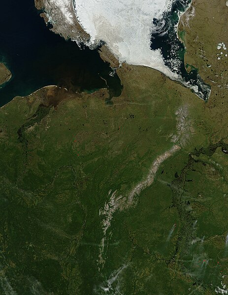
English: Pechora River
sattelite photo On July 3, 2004, sea ice still covered much of the Kara Sea in Northeastern Russia, near the western edge of Siberia, when the Moderate Resolution Imaging Spectroradiometer (MODIS) on NASA’s Aqua satellite captured this image. The southern tip of Novaya Zemlya Island curves out of the upper left corner of the image and is separated from Vaygach Island by Karskiye Vorota Strait. The narrow Yugorskiy Shar Strait, which separates Vaygach Island from mainland Russia, is clogged with sea ice. To the west, image left, the Pechora River is emptying brown, sediment-rich water into the Pechorskoye Sea. The water is probably loaded with mud as the far north thaws for the summer. In the lower right corner of the image, MODIS has detected a handful of fires, marked in red, which are sending light plumes of smoke to the southwest. |
| سروت | آپݨا کم |
| لکھاری | user:Svart |
لائسنس –
| This file is in the public domain in the United States because it was solely created by NASA. NASA copyright policy states that "NASA material is not protected by copyright unless noted". (See Template:PD-USGov, NASA copyright policy page or JPL Image Use Policy.) | ||
 |
Warnings:
|
فائل دی تریخ
فائل نو اس ویلے دی حالت وچ ویکھن واسطے تاریخ/ویلے تے کلک کرو۔
| تریخ تے ویلہ | نکی مورت | پاسے | ورتن والا | تیپّݨی کرو | |
|---|---|---|---|---|---|
| موجودہ | ۰۲:۴۷, ۲۸ مارچ ۲۰۰۶ | | ۱,۷۰۰ × ۲,۲۰۰ (۸۰۳ کلوبائٹ) | Svart~commonswiki | '''Pechora River''' sattelite photo On July 3, 2004, sea ice still covered much of the Kara Sea in Northeastern Russia, near the western edge of Siberia, when the Moderate Resolution Imaging Spectroradiometer (MODIS) on NASA’s Aqua satellite captured |
فائل دی ورتوں
تھلے دتے گئے 2 صفحے اس فائل نال جُڑدے نیں
فائل ویاپک ورتوں
ایہہ دوجے وکیاں ایس فائل نوں ورتدے نیں –
- af.wikipedia.org تے ورتوں
- ar.wikipedia.org تے ورتوں
- arz.wikipedia.org تے ورتوں
- ast.wikipedia.org تے ورتوں
- az.wikipedia.org تے ورتوں
- be.wikipedia.org تے ورتوں
- bg.wikipedia.org تے ورتوں
- bn.wikipedia.org تے ورتوں
- ca.wikipedia.org تے ورتوں
- ceb.wikipedia.org تے ورتوں
- ce.wikipedia.org تے ورتوں
- de.wikivoyage.org تے ورتوں
- diq.wikipedia.org تے ورتوں
- en.wikipedia.org تے ورتوں
- eo.wikipedia.org تے ورتوں
- es.wikipedia.org تے ورتوں
- eu.wikipedia.org تے ورتوں
- fi.wikipedia.org تے ورتوں
- fr.wikivoyage.org تے ورتوں
- ga.wikipedia.org تے ورتوں
- gl.wikipedia.org تے ورتوں
- he.wikipedia.org تے ورتوں
- hy.wikipedia.org تے ورتوں
- id.wikipedia.org تے ورتوں
- lmo.wikipedia.org تے ورتوں
- lv.wikipedia.org تے ورتوں
- mhr.wikipedia.org تے ورتوں
- mrj.wikipedia.org تے ورتوں
ایس فائل دا ویکھو ہور جگت ورتن .