فائل:Kara Sea map.png
ایس وکھالے دا ناپ: ۶۵۸ × ۵۹۹ پکسلز۔ دوجے ریزولوشنز: ۲۶۴ × ۲۴۰ پکسلز | ۵۲۷ × ۴۸۰ پکسلز | ۹۴۲ × ۸۵۸ پکسلز ۔
اصل فائل (۹۴۲ × ۸۵۸ پکسلز, فائل حجم: ۲۵۸ کلوبائٹ, MIME type: image/png)

|
This locator map image could be re-created using vector graphics as an SVG file. This has several advantages; see Commons:Media for cleanup for more information. If an SVG form of this image is available, please upload it and afterwards replace this template with
{{vector version available|new image name}}.
It is recommended to name the SVG file “Kara Sea map.svg”—then the template Vector version available (or Vva) does not need the new image name parameter. |
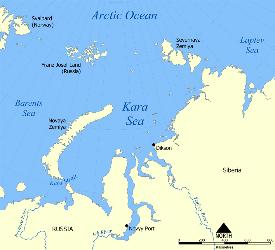
This map shows the location of the Kara Sea north of Russia. The sea is located south of the Arctic Ocean, east of the Barents Sea, west of the Laptev Sea, and is bounded by the Severnaya Zemlya and Novaya Zemlya.
Created by NormanEinstein, November 29, 2005.
میں، اس کم دے کاپیرائٹ دا مالک، اس کم نوں اس لائسنس دے مطابق چھاپدا واں:

|
کاپی کرن، ونڈن تے بدلن دی ایس ڈوکومنٹ لئی اجازت دتی جاندی اے ایہناں GNU Free Documentation License, Version 1.2 شرطاں نال یا مگروں کسے وی چھپے ورین Free Software Foundation توں بنا کسے انویرینٹ سیکشن دے، ناں فرنٹ کور لکھت تے ناں بیک کور لکھت دے۔ لسنس دی اک کاپی سیکشن وچ ہیگی اے جہدا ناں اے GNU Free Documentation License۔ |
| ایس فائل نوں کریٹو کامنز Attribution 2.5 پولینڈ لائسنس دتا گیا. | ||
| ||
| اس لائسنس دا ٹیگ GFDL دے مطابق اس فائل چ پایا گیا اے licensing update۔ |
تسیں اپنی مرضی دا لائسنس چݨ سکدے اوہ۔
derivative works
Derivative works of this file:
فائل دی تریخ
فائل نو اس ویلے دی حالت وچ ویکھن واسطے تاریخ/ویلے تے کلک کرو۔
| تریخ تے ویلہ | نکی مورت | پاسے | ورتن والا | تیپّݨی کرو | |
|---|---|---|---|---|---|
| موجودہ | ۰۱:۲۶, ۱۵ جولائی ۲۰۱۲ | | ۹۴۲ × ۸۵۸ (۲۵۸ کلوبائٹ) | Ras67 | cropped, opt. |
| ۰۳:۱۲, ۳۰ نومبر ۲۰۰۵ |  | ۹۵۲ × ۸۶۸ (۳۸۲ کلوبائٹ) | NormanEinstein | This map shows the location of the Kara Sea north of Russia. The sea is located south of the Arctic Ocean, east of the Barents Sea, west of the Laptev Sea, and is bounded by the Severnaya Zemlya and Novaya Zemlya. Created by NormanEinstein, November 29, |
فائل دی ورتوں
تھلے دتے گئے 1 صفحے اس فائل نال جُڑدے نیں
فائل ویاپک ورتوں
ایہہ دوجے وکیاں ایس فائل نوں ورتدے نیں –
- af.wikipedia.org تے ورتوں
- an.wikipedia.org تے ورتوں
- ar.wikipedia.org تے ورتوں
- avk.wikipedia.org تے ورتوں
- azb.wikipedia.org تے ورتوں
- az.wikipedia.org تے ورتوں
- bcl.wikipedia.org تے ورتوں
- be.wikipedia.org تے ورتوں
- bg.wikipedia.org تے ورتوں
- bn.wikipedia.org تے ورتوں
- br.wikipedia.org تے ورتوں
- bs.wikipedia.org تے ورتوں
- ca.wikipedia.org تے ورتوں
- cs.wikipedia.org تے ورتوں
- cy.wikipedia.org تے ورتوں
- da.wikipedia.org تے ورتوں
- de.wikipedia.org تے ورتوں
- en.wikipedia.org تے ورتوں
- en.wiktionary.org تے ورتوں
- eo.wikipedia.org تے ورتوں
- es.wikipedia.org تے ورتوں
- eu.wikipedia.org تے ورتوں
- fa.wikipedia.org تے ورتوں
- fi.wikipedia.org تے ورتوں
- frr.wikipedia.org تے ورتوں
- fr.wikipedia.org تے ورتوں
ایس فائل دا ویکھو ہور جگت ورتن .