فائل:Han Dynasty Plain map.PNG
ایس وکھالے دا ناپ: ۸۰۰ × ۳۵۲ پکسلز۔ دوجے ریزولوشنز: ۳۲۰ × ۱۴۱ پکسلز | ۶۴۰ × ۲۸۲ پکسلز | ۱,۴۲۷ × ۶۲۸ پکسلز ۔
اصل فائل (۱,۴۲۷ × ۶۲۸ پکسلز, فائل حجم: ۴۸ کلوبائٹ, MIME type: image/png)
خلاصہ
| تفصیل |
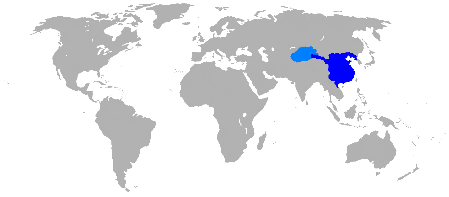
English: Map of Han Dynasty in 2 CE.
|
| تریخ | |
| سروت | Self Made, copied map from page 63 of the book Mapping History: World History (London: Cartographica, 2007), by Dr. Ian Barnes. ISBN 978-1-84573-323-0 |
| لکھاری | User:Historian of the arab people |
لائسنس –
| میں، اس کم دے کاپیرائٹ دا مالک، اس کم نوں لوکاں واسطے دیندا واں۔ اے سارے جگ واسطے لاگو اے۔ کج ملکاں چ قانونی طور تے اے ممکن نئیں اے؛ اگر انج ای اے ے: میں ہر کسے نوں اس کم نوں کسے وی مقصد واسطے ورتن دا بغیر کسے شرط دے حق دیندا واں، اگر اوہ قانون دے خلاف نا ہوۓ۔ |
فائل دی تریخ
فائل نو اس ویلے دی حالت وچ ویکھن واسطے تاریخ/ویلے تے کلک کرو۔
| تریخ تے ویلہ | نکی مورت | پاسے | ورتن والا | تیپّݨی کرو | |
|---|---|---|---|---|---|
| موجودہ | ۱۹:۳۷, ۲۶ اپریل ۲۰۱۶ | | ۱,۴۲۷ × ۶۲۸ (۴۸ کلوبائٹ) | Garam | Clear (* ref: File:China Han Dynasty 1.jpg and File:Hangunhyeon.PNG) |
| ۰۴:۵۸, ۳۰ اکتوبر ۲۰۰۸ |  | ۱,۴۲۷ × ۶۲۸ (۵۹ کلوبائٹ) | Historian of the arab people | {{Information |Description={{en|1=Map of Han dynasty, 2 AD Darkest blue is the commandaries and principalities of the Han Empire, light blue is the Tarim Basin protectorate}} |Source=Self Made, copied map from page 63 of the book, "MAPPING HISTORY WORLD H |
فائل دی ورتوں
تھلے دتے گئے 1 صفحے اس فائل نال جُڑدے نیں
فائل ویاپک ورتوں
ایہہ دوجے وکیاں ایس فائل نوں ورتدے نیں –
- ar.wikipedia.org تے ورتوں
- as.wikipedia.org تے ورتوں
- azb.wikipedia.org تے ورتوں
- de.wikipedia.org تے ورتوں
- en.wikipedia.org تے ورتوں
- et.wikipedia.org تے ورتوں
- fi.wikipedia.org تے ورتوں
- fo.wikipedia.org تے ورتوں
- he.wikipedia.org تے ورتوں
- id.wikipedia.org تے ورتوں
- sco.wikipedia.org تے ورتوں
- ur.wikipedia.org تے ورتوں