فائل:Federal subjects of Russia by population dencity.svg

Size of this PNG preview of this SVG file: ۸۰۰ × ۴۳۴ پکسلز. دوجے ریزولوشنز: ۳۲۰ × ۱۷۳ پکسلز | ۶۴۰ × ۳۴۷ پکسلز | ۱,۰۲۴ × ۵۵۵ پکسلز | ۱,۲۸۰ × ۶۹۴ پکسلز | ۲,۵۶۰ × ۱,۳۸۸ پکسلز | ۵,۰۰۰ × ۲,۷۱۰ پکسلز ۔
اصل فائل (ایس وی جی فائل، پکسل:۵,۰۰۰ × ۲,۷۱۰، فائل سائز: ۲۴۰ کلوبائٹ)
Crimea is Ukraine

|
The boundaries on this map show the de facto situation. This is just one of several different views on the subject (see COM:NPOV). |
خلاصہ
| تفصیل |
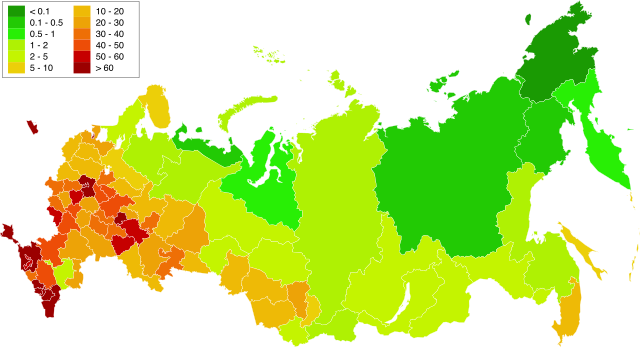
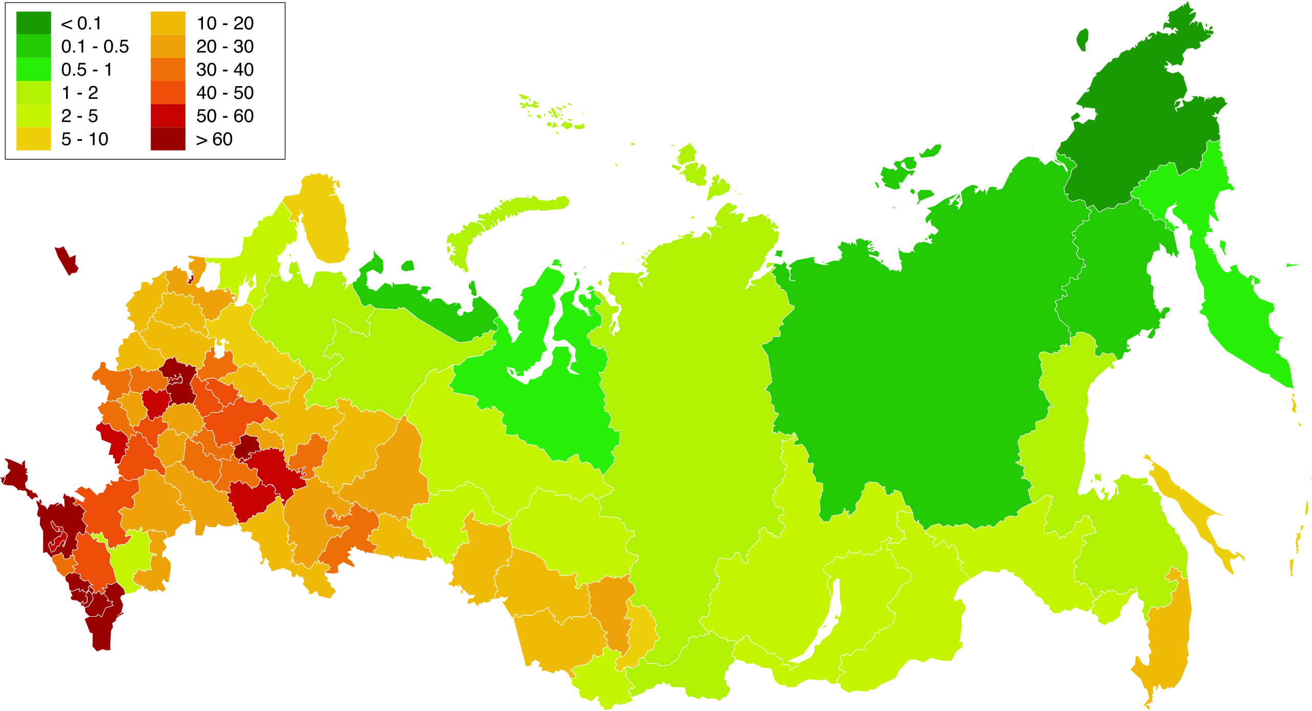
English: Map of population density in the subjects of the Russian Federation. The population density of Arkhangelsk Oblast and Tyumen Oblast was calculated together with the population and area of the respective Autonomous Okrugs belonging to them.
Русский: Карта плотности населения в субъектах Российской Федерации. При расчёте плотностей населения Архангельской и Тюменской области учитывались площади и населения входящих в них автономных округов. |
| تریخ | 1.02.2010 20:39:08 MSK |
| سروت | Russia - blank map (2009-01).svg |
| لکھاری | آپݨا کم. Original uploader was Алексей Глушков at ru.wikipedia |
| دوجے ورژن |
Other views related to this image
|

.svg)
لائسنس –
| میں، اس کم دے کاپیرائٹ دا مالک، اس کم نوں لوکاں واسطے دیندا واں۔ اے سارے جگ واسطے لاگو اے۔ کج ملکاں چ قانونی طور تے اے ممکن نئیں اے؛ اگر انج ای اے ے: میں ہر کسے نوں اس کم نوں کسے وی مقصد واسطے ورتن دا بغیر کسے شرط دے حق دیندا واں، اگر اوہ قانون دے خلاف نا ہوۓ۔ |
فائل دی تریخ
فائل نو اس ویلے دی حالت وچ ویکھن واسطے تاریخ/ویلے تے کلک کرو۔
| تریخ تے ویلہ | نکی مورت | پاسے | ورتن والا | تیپّݨی کرو | |
|---|---|---|---|---|---|
| موجودہ | ۲۱:۵۸, ۲۰ مارچ ۲۰۱۹ | | ۵,۰۰۰ × ۲,۷۱۰ (۲۴۰ کلوبائٹ) | Gajmar | Kaluga Oblast |
| ۰۱:۴۶, ۲۰ مارچ ۲۰۱۹ |  | ۵,۰۰۰ × ۲,۷۱۰ (۲۴۰ کلوبائٹ) | Gajmar | new colour scheme | |
| ۰۱:۱۷, ۲۰ مارچ ۲۰۱۹ |  | ۵,۰۰۰ × ۲,۷۱۰ (۲۳۶ کلوبائٹ) | Gajmar | update (01.01.2019) | |
| ۲۰:۳۹, ۳ مارچ ۲۰۱۳ |  | ۱,۶۵۰ × ۱,۰۰۰ (۱۴۱ کلوبائٹ) | Gajmar | 1.01.2013 | |
| ۲۱:۵۳, ۲۸ مئی ۲۰۱۱ |  | ۱,۶۵۰ × ۱,۰۰۰ (۱۴۰ کلوبائٹ) | Gajmar | Update the data according to Russian census of 2010 (as of October 14). Indications of population density changed in Karachay-Cherkess Republic, Republic of Mari El, Leningrad Oblast and the Jewish Autonomous Oblast. / Обновление данных с | |
| ۲۳:۲۲, ۱ فروری ۲۰۱۰ |  | ۱,۶۵۰ × ۱,۰۰۰ (۱۰۹ کلوبائٹ) | Алексей Глушков | {{Information |Description={{en|1=Population density map in subjects of the Russian Federation. At calculation of population density Arkhangelsk and the Tyumen region the areas and the population of autonomous regions entering into them were considered.}} |
فائل دی ورتوں
تھلے دتے گئے 1 صفحے اس فائل نال جُڑدے نیں
فائل ویاپک ورتوں
ایہہ دوجے وکیاں ایس فائل نوں ورتدے نیں –
- af.wikipedia.org تے ورتوں
- ar.wikipedia.org تے ورتوں
- az.wikipedia.org تے ورتوں
- bg.wikipedia.org تے ورتوں
- de.wikipedia.org تے ورتوں
- es.wikipedia.org تے ورتوں
- eu.wikipedia.org تے ورتوں
- fa.wikipedia.org تے ورتوں
- hu.wikipedia.org تے ورتوں
- kk.wikipedia.org تے ورتوں
- ps.wikipedia.org تے ورتوں
- ru.wikipedia.org تے ورتوں
- te.wikipedia.org تے ورتوں
- zh.wikipedia.org تے ورتوں