فائل:Democratic Republic of Georgia map.jpg
ایس وکھالے دا ناپ: ۸۰۰ × ۵۶۱ پکسلز۔ دوجے ریزولوشنز: ۳۲۰ × ۲۲۴ پکسلز | ۶۴۰ × ۴۴۸ پکسلز | ۱,۰۲۴ × ۷۱۸ پکسلز | ۱,۲۱۳ × ۸۵۰ پکسلز ۔
اصل فائل (۱,۲۱۳ × ۸۵۰ پکسلز, فائل حجم: ۴۴۲ کلوبائٹ, MIME type: image/jpeg)

|
This history map image could be re-created using vector graphics as an SVG file. This has several advantages; see Commons:Media for cleanup for more information. If an SVG form of this image is available, please upload it and afterwards replace this template with
{{vector version available|new image name}}.
It is recommended to name the SVG file “Democratic Republic of Georgia map.svg”—then the template Vector version available (or Vva) does not need the new image name parameter. |


خلاصہ
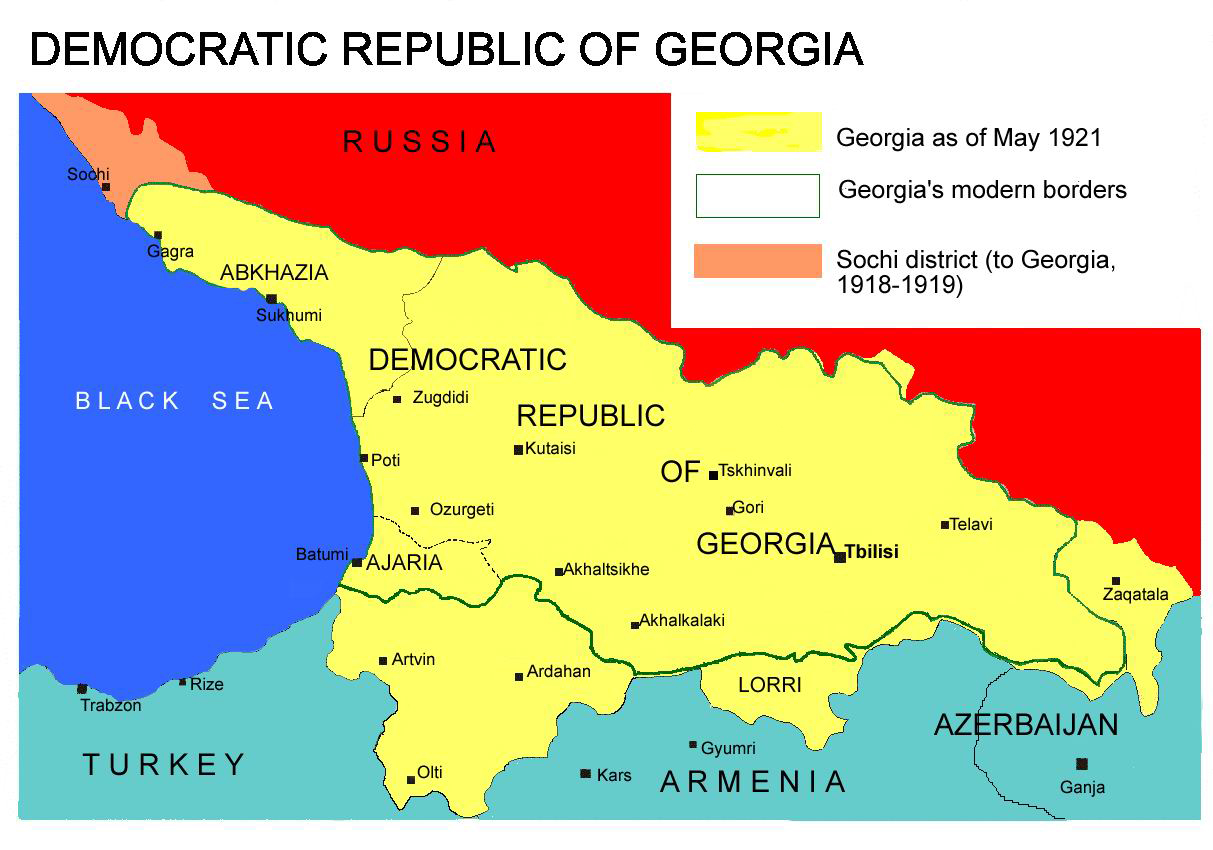
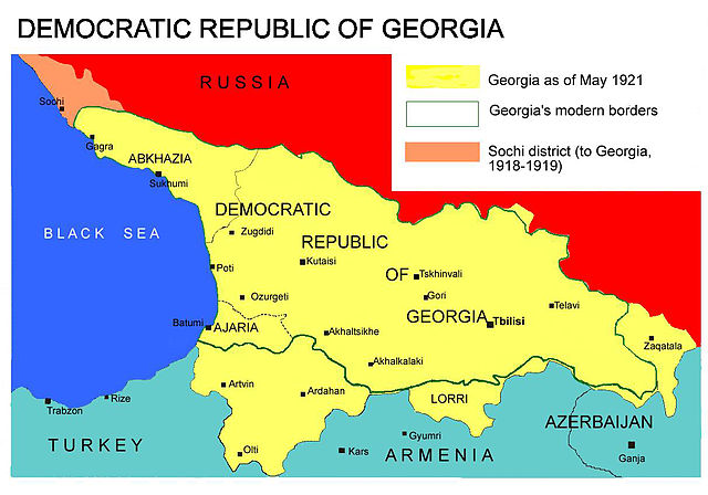
Democratic Republic of Georgia map, 1918-1921
Source: english wikipedia
Uploaded by user:Kober
لائسنس –
| میں، اس کم دے کاپیرائٹ دا مالک، اس کم نوں لوکاں واسطے دیندا واں۔ اے سارے جگ واسطے لاگو اے۔ کج ملکاں چ قانونی طور تے اے ممکن نئیں اے؛ اگر انج ای اے ے: میں ہر کسے نوں اس کم نوں کسے وی مقصد واسطے ورتن دا بغیر کسے شرط دے حق دیندا واں، اگر اوہ قانون دے خلاف نا ہوۓ۔ |
فائل دی تریخ
فائل نو اس ویلے دی حالت وچ ویکھن واسطے تاریخ/ویلے تے کلک کرو۔
| تریخ تے ویلہ | نکی مورت | پاسے | ورتن والا | تیپّݨی کرو | |
|---|---|---|---|---|---|
| موجودہ | ۱۸:۲۶, ۷ اپریل ۲۰۱۳ | | ۱,۲۱۳ × ۸۵۰ (۴۴۲ کلوبائٹ) | Giorgi Balakhadze | At that time (May, 1921 year) there was no South Ossetia, it was created in 1922. |
| ۱۸:۲۱, ۷ اپریل ۲۰۱۳ |  | ۱,۲۱۳ × ۸۵۰ (۴۴۲ کلوبائٹ) | Giorgi Balakhadze | Reverted to version as of 13:08, 7 April 2013 | |
| ۱۸:۱۵, ۷ اپریل ۲۰۱۳ |  | ۱,۲۱۳ × ۸۵۰ (۴۴۲ کلوبائٹ) | Giorgi Balakhadze | At that time (1921 year) there was no South Ossetia, it was created 1922. | |
| ۱۸:۰۸, ۷ اپریل ۲۰۱۳ |  | ۱,۲۱۳ × ۸۵۰ (۴۴۲ کلوبائٹ) | Giorgi Balakhadze | At that time (1921 year) there was no South Osetia. | |
| ۲۱:۴۶, ۲۶ دسمبر ۲۰۰۵ |  | ۱,۲۱۳ × ۸۵۰ (۱۱۱ کلوبائٹ) | Hardscarf | Democratic Republic of Georgia map, 1918-1921 Source: [http://en.wikipedia.org/wiki/Image:Democratic_Republic_of_Georgia_map.jpg english wikipedia] Uploaded by [http://en.wikipedia.org/wiki/User:Kober user:Kober] Category:Historical maps of Georgia |
فائل دی ورتوں
تھلے دتے گئے 1 صفحے اس فائل نال جُڑدے نیں
فائل ویاپک ورتوں
ایہہ دوجے وکیاں ایس فائل نوں ورتدے نیں –
- bg.wikipedia.org تے ورتوں
- bn.wikipedia.org تے ورتوں
- da.wikipedia.org تے ورتوں
- de.wikipedia.org تے ورتوں
- en.wikipedia.org تے ورتوں
- en.wikibooks.org تے ورتوں
- fa.wikipedia.org تے ورتوں
- id.wikipedia.org تے ورتوں
- ka.wikipedia.org تے ورتوں
- lt.wikipedia.org تے ورتوں
- pl.wikipedia.org تے ورتوں
- pt.wikipedia.org تے ورتوں
- ru.wikipedia.org تے ورتوں
- sk.wikipedia.org تے ورتوں
- sr.wikipedia.org تے ورتوں
- tr.wikipedia.org تے ورتوں
- uk.wikipedia.org تے ورتوں
- ur.wikipedia.org تے ورتوں
- zh.wikipedia.org تے ورتوں