فائل:Cairngorms National Park UK location map.svg

Size of this PNG preview of this SVG file: ۷۲۸ × ۵۹۹ پکسلز. دوجے ریزولوشنز: ۲۹۲ × ۲۴۰ پکسلز | ۵۸۳ × ۴۸۰ پکسلز | ۹۳۳ × ۷۶۸ پکسلز | ۱,۲۴۴ × ۱,۰۲۴ پکسلز | ۲,۴۸۸ × ۲,۰۴۸ پکسلز | ۱,۴۲۵ × ۱,۱۷۳ پکسلز ۔
اصل فائل (ایس وی جی فائل، پکسل:۱,۴۲۵ × ۱,۱۷۳، فائل سائز: ۱.۳۵ میگابائٹ)
| تفصیل |
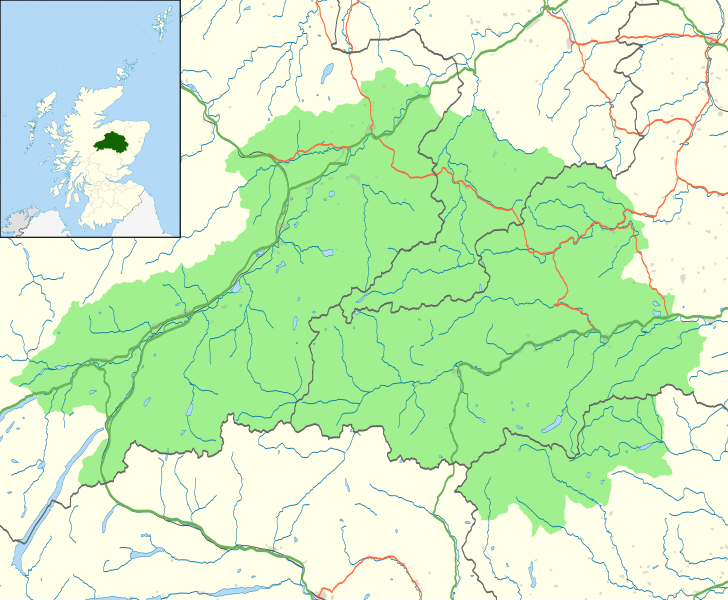
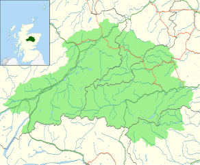
Map of the Cairngorms National Park, UK with the following information shown:
Equirectangular map projection on WGS 84 datum, with N/S stretched 180% Geographic limits:
|
| تریخ | |
| سروت |
Office of National Statistics Geography
|
| لکھاری | Nilfanion, created using Ordnance Survey data |
| اجازت (فائل نوں دوبارہ ورتنا) |
ایس فائل نوں کریٹو کامنز Attribution 2.5 پولینڈ لائسنس دتا گیا. کس دے ناں: Contains Ordnance Survey data © Crown copyright and database right
|
فائل دی تریخ
فائل نو اس ویلے دی حالت وچ ویکھن واسطے تاریخ/ویلے تے کلک کرو۔
| تریخ تے ویلہ | نکی مورت | پاسے | ورتن والا | تیپّݨی کرو | |
|---|---|---|---|---|---|
| موجودہ | ۰۲:۴۶, ۳۰ اکتوبر ۲۰۱۰ | | ۱,۴۲۵ × ۱,۱۷۳ (۱.۳۵ میگابائٹ) | Nilfanion | {{Information |Description=Map of the Cairngorms National Park, UK with the following information shown: *National Park boundary *Administrative borders *Coastline, lakes and rivers *Roads and railways *Urban areas Equirect |
فائل دی ورتوں
تھلے دتے گئے 1 صفحے اس فائل نال جُڑدے نیں
فائل ویاپک ورتوں
ایہہ دوجے وکیاں ایس فائل نوں ورتدے نیں –
- da.wikipedia.org تے ورتوں
- en.wikipedia.org تے ورتوں
- eu.wikipedia.org تے ورتوں
- fi.wikipedia.org تے ورتوں
- it.wikipedia.org تے ورتوں
- lt.wikipedia.org تے ورتوں
- nl.wikipedia.org تے ورتوں