فائل:Çorum districts.png

ایس وکھالے دا ناپ: ۷۷۶ × ۶۰۰ پکسلز۔ دوجے ریزولوشنز: ۳۱۱ × ۲۴۰ پکسلز | ۶۲۱ × ۴۸۰ پکسلز | ۹۹۴ × ۷۶۸ پکسلز | ۱,۰۵۶ × ۸۱۶ پکسلز ۔
اصل فائل (۱,۰۵۶ × ۸۱۶ پکسلز, فائل حجم: ۳۶ کلوبائٹ, MIME type: image/png)
خلاصہ
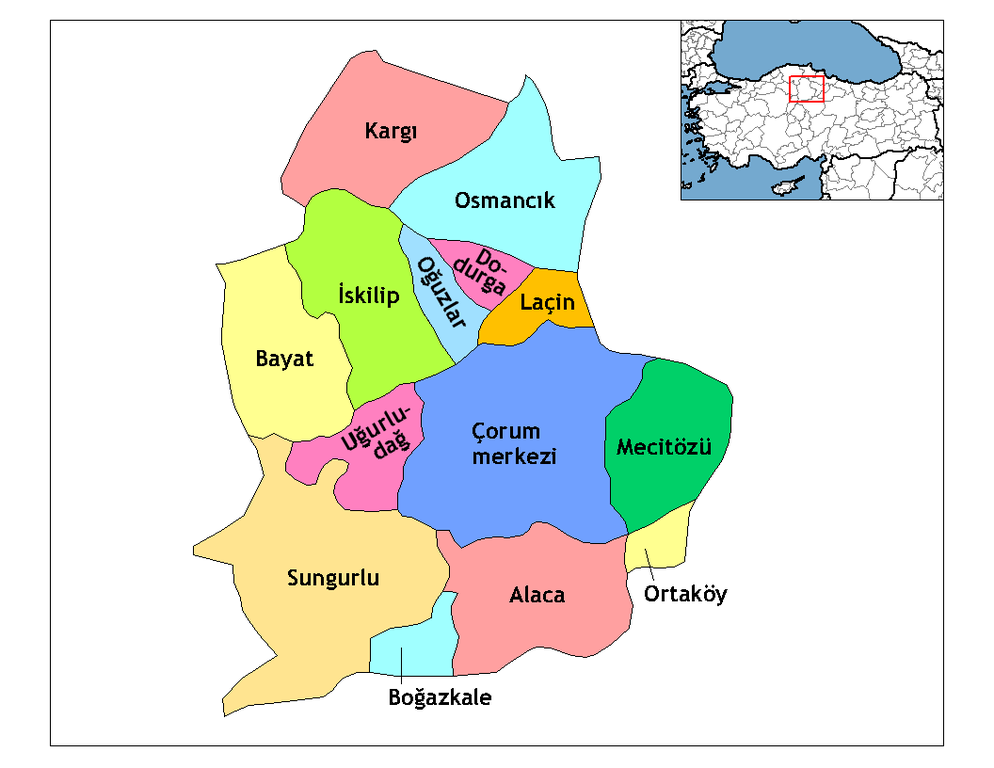
Description=Map of the districts of Çorum province in Turkey. Source= Image:Çorum__districts.png Author= User:Rarelibra,1 December 2006 (UTC) for public domain use, using MapInfo Professional v8.5 and various mapping resources. Edited by One Homo Sapiens Corrected text where İ,Ş,ı,ğ,or ş occurs in name. Source: [statoids-com]. Increased font size and enhanced color differences among adjacent districts. , reload by User:Mustafa_Akalp to match the Province name in en:wiki.
| میں، اس کم دے کاپیرائٹ دا مالک، اس کم نوں لوکاں واسطے دیندا واں۔ اے سارے جگ واسطے لاگو اے۔ کج ملکاں چ قانونی طور تے اے ممکن نئیں اے؛ اگر انج ای اے ے: میں ہر کسے نوں اس کم نوں کسے وی مقصد واسطے ورتن دا بغیر کسے شرط دے حق دیندا واں، اگر اوہ قانون دے خلاف نا ہوۓ۔ |
لائسنس –
میں، اس کم دے کاپیرائٹ دا مالک، اس کم نوں اس لائسنس دے مطابق چھاپدا واں:

|
کاپی کرن، ونڈن تے بدلن دی ایس ڈوکومنٹ لئی اجازت دتی جاندی اے ایہناں GNU Free Documentation License, Version 1.2 شرطاں نال یا مگروں کسے وی چھپے ورین Free Software Foundation توں بنا کسے انویرینٹ سیکشن دے، ناں فرنٹ کور لکھت تے ناں بیک کور لکھت دے۔ لسنس دی اک کاپی سیکشن وچ ہیگی اے جہدا ناں اے GNU Free Documentation License۔ |
| ایس فائل نوں کریٹو کامنز Attribution 2.5 پولینڈ لائسنس دتا گیا. | ||
| ||
| اس لائسنس دا ٹیگ GFDL دے مطابق اس فائل چ پایا گیا اے licensing update۔ |
تسیں اپنی مرضی دا لائسنس چݨ سکدے اوہ۔
فائل دی تریخ
فائل نو اس ویلے دی حالت وچ ویکھن واسطے تاریخ/ویلے تے کلک کرو۔
| تریخ تے ویلہ | نکی مورت | پاسے | ورتن والا | تیپّݨی کرو | |
|---|---|---|---|---|---|
| موجودہ | ۰۹:۲۴, ۲۹ دسمبر ۲۰۰۸ | | ۱,۰۵۶ × ۸۱۶ (۳۶ کلوبائٹ) | One Homo Sapiens | Corrected text where İ,Ş,ı,ğ,or ş occurs in name. Source: [statoids-com]. Increased font size and enhanced color differences among adjacent districts. |
| ۱۰:۳۸, ۲ فروری ۲۰۰۷ |  | ۱,۰۵۶ × ۸۱۶ (۴۵ کلوبائٹ) | Makalp | Description=Map of the districts of Çorum province in Turkey. Source= Image:Çorum__districts.png Author= User:Rarelibra,1 December 2006 (UTC) for public domain use, using MapInfo Professional v8.5 and various mapping resources. , reloa |
فائل دی ورتوں
تھلے دتے گئے 1 صفحے اس فائل نال جُڑدے نیں
فائل ویاپک ورتوں
ایہہ دوجے وکیاں ایس فائل نوں ورتدے نیں –
- arz.wikipedia.org تے ورتوں
- ast.wikipedia.org تے ورتوں
- ca.wikipedia.org تے ورتوں
- ce.wikipedia.org تے ورتوں
- cs.wikipedia.org تے ورتوں
- de.wikipedia.org تے ورتوں
- de.wikivoyage.org تے ورتوں
- diq.wikipedia.org تے ورتوں
- en.wikipedia.org تے ورتوں
- Çorum Province
- User talk:Rarelibra/Maps4
- Districts of Turkey
- Governor of Çorum
- List of populated places in Çorum Province
- Ortaköy District, Çorum
- Uğurludağ District
- Alaca District
- Çorum District
- Bayat District, Çorum
- Boğazkale District
- Dodurga District
- İskilip District
- Kargı District
- Laçin District
- Mecitözü District
- Oğuzlar District
- Osmancık District
- Sungurlu District
- en.wiktionary.org تے ورتوں
- eo.wikipedia.org تے ورتوں
- es.wikipedia.org تے ورتوں
ایس فائل دا ویکھو ہور جگت ورتن .